By: Louis Sahagun ~ L.A. Times ~ February 18, 2019
Scientists call it California’s “other big one,” and they say it could cause three times as much damage as a major earthquake ripping along the San Andreas Fault.
Although it might sound absurd to those who still recall five years of withering drought and mandatory water restrictions, researchers and engineers warn that California may be due for rain of biblical proportions — or what experts call an ARkStorm.
This rare mega-storm — which some say is rendered all the more inevitable due to climate change — would last for weeks and send more than 1.5 million people fleeing as floodwaters inundated cities and formed lakes in the Central Valley and Mojave Desert, according to the U.S. Geological Survey. Officials estimate the structural and economic damage from an ARkStorm (for Atmospheric River 1,000) would amount to more than $725 billion statewide.
In heavily populated areas of the Los Angeles Basin, epic runoff from the San Gabriel Mountains could rapidly overwhelm a flood control dam on the San Gabriel river and unleash floodwaters from Pico Rivera to Long Beach, says a recent analysis by the U.S. Army Corps of Engineers.
In a series of recent public hearings, corps officials told residents that the 60-year-old Whittier Narrows Dam no longer met the agency’s tolerable-risk guidelines and could fail in the event of a very large, very rare storm, such as the one that devastated California more than 150 years ago.
Specifically, federal engineers found that the Whittier Narrows structure could fail if water were to flow over its crest or if seepage eroded the sandy soil underneath. In addition, unusually heavy rains could trigger a premature opening of the dam's massive spillway on the San Gabriel River, releasing more than 20 times what the downstream channel could safely contain within its levees.
The corps is seeking up to $600 million in federal funding to upgrade the 3-mile-long dam, and say the project has been classified as the agency’s highest priority nationally, due to the risk of “very significant loss of life and economic impacts.”
The funding will require congressional approval, according to Doug Chitwood, lead engineer on the project.
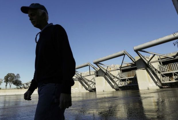
Standing atop the 56-foot-tall dam recently, Chitwood surveyed the sprawl of working-class homes, schools and commercial centers about 13 miles south of Los Angeles and said, “All you see could be underwater.”
The dam — which stretches from Montebello to Pico Rivera and crosses both the San Gabriel and Rio Hondo rivers — is one of a number of flood control facilities overseen by the corps. Throughout much of the year, it contains little water.
A government study, however, used computer models to estimate the effects of 900-year, 7,500-year and 18,000-year storm events.
In each case, catastrophic flooding could extend from Pico Rivera to Long Beach, inundating cities including Artesia, Bell Gardens, Bellflower, Carson, Cerritos, Commerce, Compton, Cypress, Downey, Hawaiian Gardens, La Palma, Lakewood, Long Beach, Lynwood, Montebello, Norwalk, Paramount, Rossmoor, Santa Fe Springs, Seal Beach and Whittier. Officials say as many as 1 million people could be affected.
Among the communities hardest hit in a dam failure would be Pico Rivera, a city of about 63,000 people immediately below the dam. In a worst-case scenario, it could be hit with water 20 feet deep, and evacuation routes would be turned into rivers. Downey could see 15 feet of water; Santa Fe Springs, 10 feet.
In recent years, officials with the U.S. Department of Interior and the U.S. Geological Survey have sought to raise awareness of the threat of mega-storms and promote emergency preparedness. Part of the challenge, however, has been characterizing the scale of such storms. When scientists speak of a 900-year storm, that does not mean the storm will occur every 900 years, or that such a storm cannot happen two years in a row. It means that such a storm has a 1 in 900 — or .1% — chance of occurring in any given year.
The estimates used by the U.S. Army Corps of Engineers are intended to protect the region from a storm similar to the one that hit California during the rainy season of 1861-1862. That’s when a series of intense storms hammered the state for 45 days and dropped 36 inches of rain on Los Angeles. So much water fell that it was impossible to cross the Central Valley without a boat, and the state capital was moved temporarily from Sacramento to San Francisco.
The false sense of security included in the phrase ‘900-year flood’ combined with the promises of 20th century water infrastructure have put us in a bind.